Tornado Warning: Severe Storms Set to Slam Central and Eastern U.S. This Weekend
A prolonged period of severe weather, which includes the potential threat of significant tornadoes, is forecasted over the weekend across many parts of the central and eastern United States.
Storms kick off Saturday across the central and southern Plains, blossom in parts of Oklahoma, Kansas and Missouri. But Sunday looks to feature the greatest threat — more than 25 million people are in an enhanced (Level 3 out of 5) risk zone for severe weather, which covers much of the Mississippi and Ohio Valleys.
“The Storm Prediction Center has issued a warning for an extensive/severe weather event,” they stated. “Large hail, destructive gusts, and potent twisters are anticipated.”
By early week, the severe weather threat will move towards the East Coast. Strong storms might extend from Boston all the way down to Jacksonville, Florida; however, the higher concentration of potentially destructive winds and sporadic tornadoes will likely focus on North Carolina, South Carolina, and Georgia.
Additional bouts of intense weather might hit the Plains as soon as next Wednesday, coinciding with the arrival of another major storm system moving eastward.
The basic setup
By midday Friday, a vortex of frigid upper-level air, along with low pressure and rotation, had formed off the coast of the Pacific Northwest. This low-pressure system is expected to move eastward in the following few days.
Before it arrives, winds from the south will bring heat and humidity northward from the Gulf. This will create an unstable environment, essentially providing fuel for thunderstorms, aiding their development.
The low-pressure system is driving the jet stream further south, resulting in what’s called a "trough." This causes the jet stream—the current of high-speed wind in the higher levels of the atmosphere—to move right above the warm, moist air mass. Additionally, these increased winds have the potential to make certain thunderstorms spin and may help generate powerful gusts capable of causing damage.
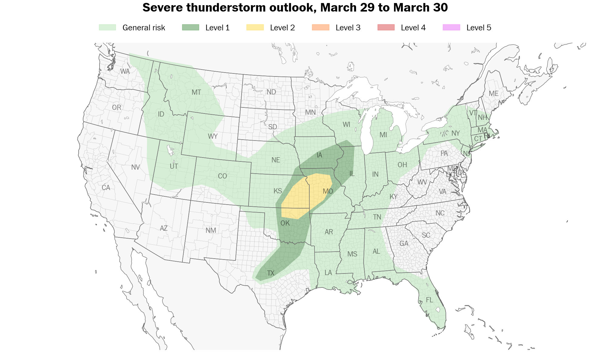
Saturday’s threat
Areas at risk: A slight (Level 2 out of 5) severe weather risk includes Kansas City; Wichita, Kansas; and Tulsa. A marginal (Level 1 out of 5) risk stretches down to Dallas and Oklahoma City.
Outlook: Thunderstorms are likely to develop along a dry line, which marks where arid desert air meets moister conditions further east. The area with higher storm activity will be concentrated in Kansas and western Missouri, particularly near the low-pressure system.
Further south throughout northern and central Oklahoma, it remains uncertain whether the environment will be conducive for generating a storm. Should a storm develop, it could likely result in hail as large as chicken eggs or even bigger.
Sunday’s threat
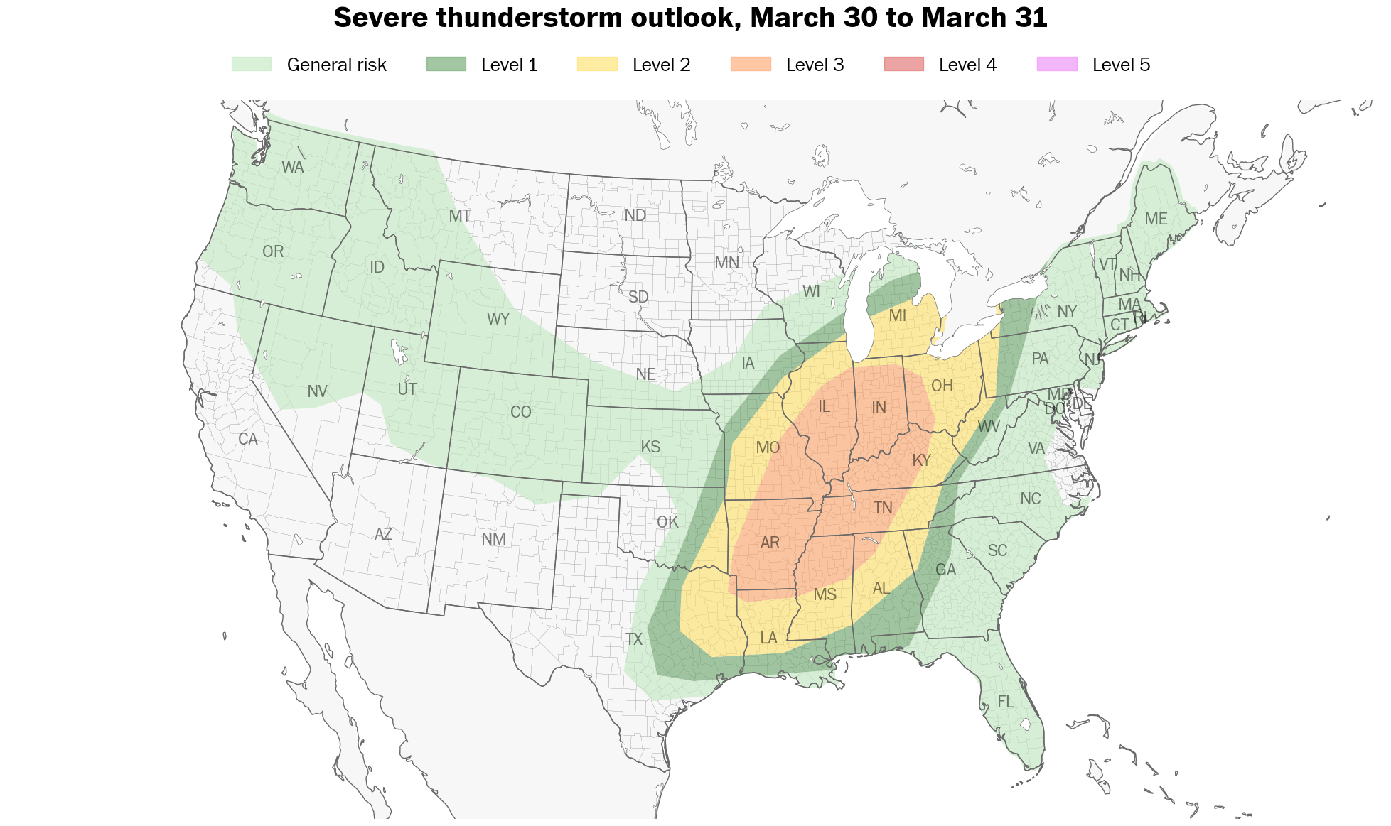
Areas at risk: A heightened (Risk Level 3 out of 5) alert for extreme weather conditions extends from the Midwest through the southern Great Lakes region down to northern Louisiana. This encompasses large portions of the Mississippi and Ohio River valleys, affecting cities such as Indianapolis, Memphis, Nashville, St. Louis, and Cincinnati. Meanwhile, a less intense Risk Level 2 area includes Chicago and Detroit.
Outlook: A low-pressure system moving past the northern region of the Great Lakes will push warm, moist air from the Gulf of Mexico upwards. Given how far north this low pressure travels, it creates a vast area of heated air known as the warm sector. This expansive warming contributes significantly to the extensive reach of potential thunderstorms.
The worry is that wind sheer—or variations in wind speed and direction at different altitudes—will be significant. Storms reaching sufficient heights would consequently experience these varying winds and exhibit rotation. Some of them might develop into powerful tornadoes.
Powerful winds with speeds exceeding 60 miles per hour may occur. Additionally, extremely cold conditions high up in the atmosphere might lead to the formation of sizable hailstones.
Monday’s threat
Areas at risk: There is a minor (Level 2 out of 5) threat of severe weather affecting regions stretching from just south of Boston down to the northern part of the Florida peninsula. This encompasses cities such as New York City, Philadelphia, Washington, D.C., Richmond, Raleigh in North Carolina, Charlotte, and Jacksonville in Florida.
Outlook: Since the atmosphere over the Southeast will be hotter and wetter, this could lead to larger areas with stronger thunderstorms during the afternoon hours. In contrast, the available energy for storms might not be as robust across the Mid-Atlantic and Northeast regions.
Nevertheless, as powerful jets of air rush above us, some thunderstorms might generate severe wind bursts or even an occasional tornado. Weather experts aim to improve their predictions in the coming days.


Comments
Post a Comment